What the what?
So I'm planning next steps, and in checking a map to plan my steps between Horatio, where I stopped last time, and, oh, say, somewhere up on Lake Wateree. Checking into routes, I stumble onto a map from 1733 by Edward Mosely, which includes a detail of an Indian trading path. It also has a kind of weird representation of the Neuse River, which runs through Raleigh, where I live, so to check on its trustworthiness I brought up Google Maps to do a side-by-side.
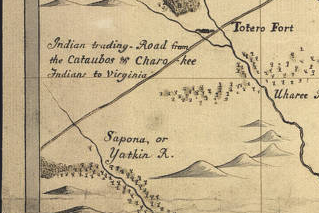 Above, Indian Trading Road. At right, a view of the Neuse that for some reason got me wondering about something. | 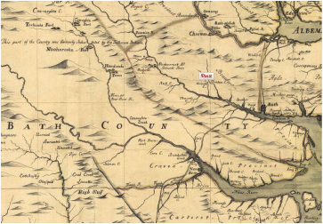 |
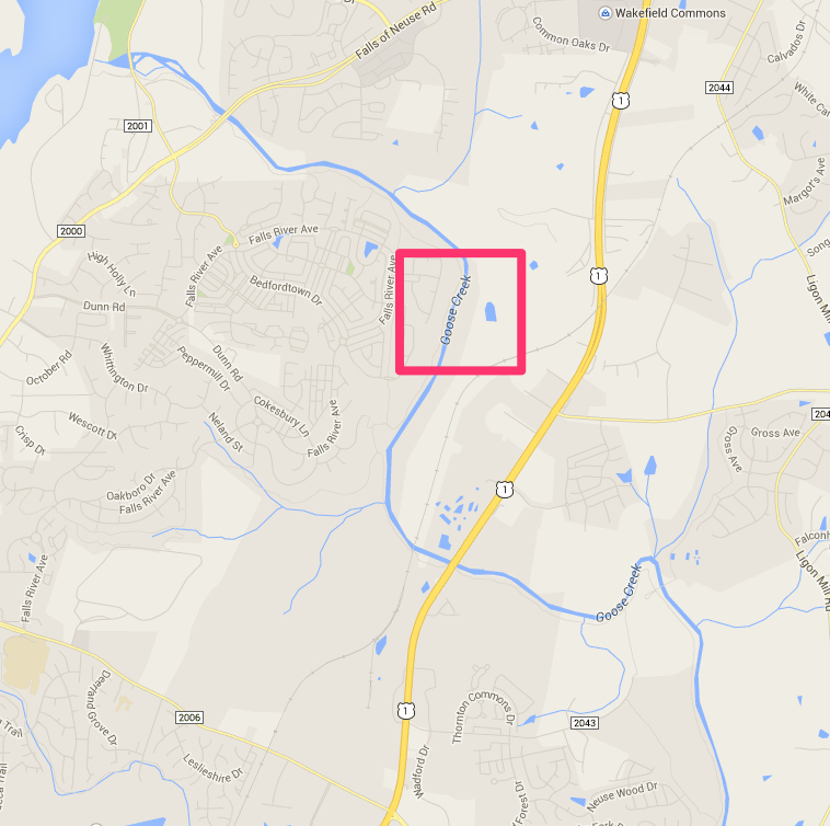
When I opened up Google Maps, I found that the Neuse River, which has run through this part of the world for thousands of years and perhaps much longer, has suddenly been renamed the Goose Creek, according to Google Maps.
This is the type of thing that will get you going.
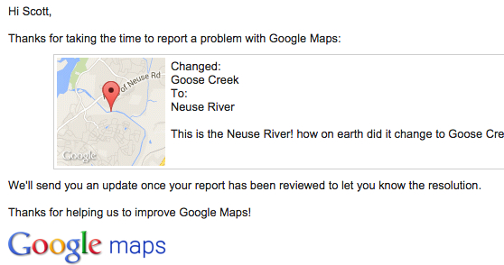
So, thing one, I sent them a notice on their WTF page, which reassuringly promises to keep me updated on the progress of the correction. They even sent me an email. So far no change.
Now, I'm sure this will be fixed before long, but what I'm trying to figure out is how it got changed to the wrong thing in the first place. This interview from Science Friday only Feb. 20 discusses the people behind Google's Project Ground Truth (here's a good explanation of the project by CNET), which plans, according to its website, "to map the world from authoritative data sources, via a unique mix of algorithms and elbow grease." Craig Miller, of Wired's Map Lab blog, tells SciFri that keeping Google Maps up to date is quite a project: "New roads are being built, housing developments pop up, shopping malls get torn down. So there's a lot of change to keep the maps accurate and up to date." Google uses artificial intelligence -- from all those satellite and street view images -- and all kinds of other data to share the vast amounts of information its maps provide.
As you know, the maps still make mistakes -- this is far from the first error the Lawson Trek has encountered along the way. Miller says Google gets tens of thousands of error reports every day. So we can't be enormously surprised that even a day later the Neuse is still the Goose (Apple Maps, of all places, still has it right, by the way; so does Openstreetmap, the Google Maps predecessor that uses government data and crowd sources in a sort of wiki arrangement.)
This is the type of thing that will get you going.
So, thing one, I sent them a notice on their WTF page, which reassuringly promises to keep me updated on the progress of the correction. They even sent me an email. So far no change.
Now, I'm sure this will be fixed before long, but what I'm trying to figure out is how it got changed to the wrong thing in the first place. This interview from Science Friday only Feb. 20 discusses the people behind Google's Project Ground Truth (here's a good explanation of the project by CNET), which plans, according to its website, "to map the world from authoritative data sources, via a unique mix of algorithms and elbow grease." Craig Miller, of Wired's Map Lab blog, tells SciFri that keeping Google Maps up to date is quite a project: "New roads are being built, housing developments pop up, shopping malls get torn down. So there's a lot of change to keep the maps accurate and up to date." Google uses artificial intelligence -- from all those satellite and street view images -- and all kinds of other data to share the vast amounts of information its maps provide.
As you know, the maps still make mistakes -- this is far from the first error the Lawson Trek has encountered along the way. Miller says Google gets tens of thousands of error reports every day. So we can't be enormously surprised that even a day later the Neuse is still the Goose (Apple Maps, of all places, still has it right, by the way; so does Openstreetmap, the Google Maps predecessor that uses government data and crowd sources in a sort of wiki arrangement.)
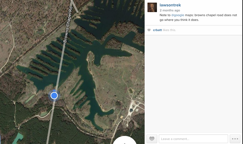
We followed Browns Chapel Road according to many map sources and lived to regret it. It's that kind of world.
This mapping business is worth thinking about. I learned a bit about it from Dale Loberger (and expect to learn more soon), but as I walk, I am coming to recognize that my experience of my journey is profoundly affected by my maps. I can check my phone, my medium-scale DeLorme maps that I copy from DeLorme's indispensable gazetteers before each journey. On its website DeLorme characterizes those state atlas-gazetteers as "mapping America's back roads," which is exactly fair. You'd never want a DeLorme map book if you were looking for an address in a city or town, but looking for roads -- everything from vague farm roads to interstate highways -- that lead from one place to another? DeLorme is your source, and every Lawsonian I know carries a well-loved DeLorme around along with his or her copy of Lawson.
Now Lawson himself created a map, though the only important information advances on it were names and placements of Indian tribes. And he'd have been familiar with earlier maps, though in 1700 maps of the Carolinas were pretty vague.
Now Lawson himself created a map, though the only important information advances on it were names and placements of Indian tribes. And he'd have been familiar with earlier maps, though in 1700 maps of the Carolinas were pretty vague.
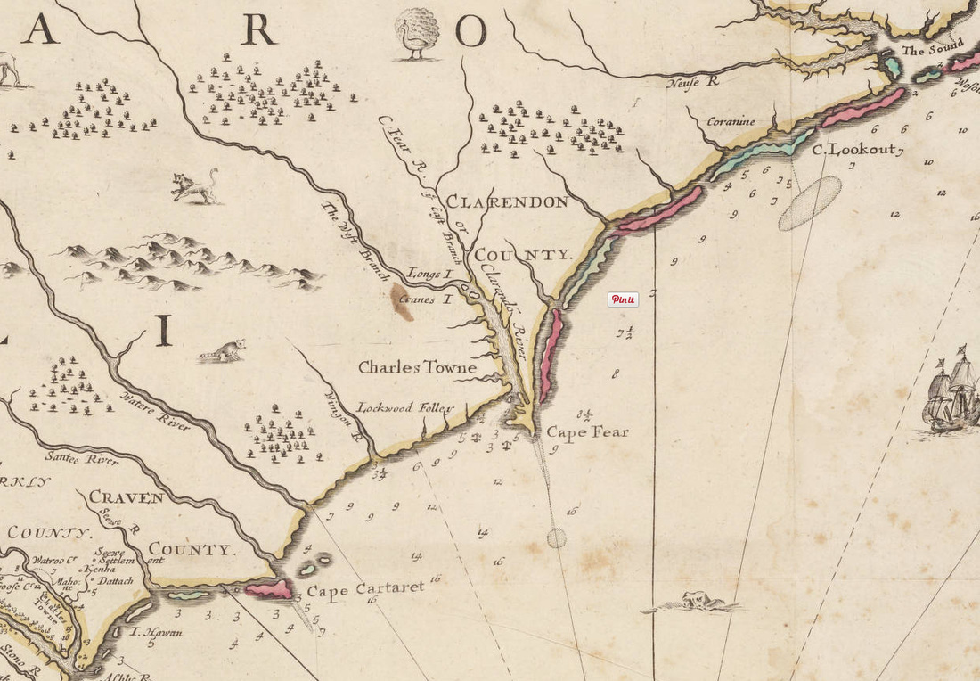
This map was produced in London in 1690, and Lawson likely had something like it. Note that it got the Neuse right but the Wateree wrong.
I'm interested in how our maps affect our perceptions of reality: "the map is not the territory," as Alfred Korzybski famously said in 1931, expressing what is called the map-territory relation. The map is a representation of the territory, and it's always got room for error and improvement. Whether it's uncertain maps before or by Lawson or Google Maps suddenly going flooey after years of being right, or the globe in my office that shows the USSR -- or the amazing 30-foot Mapparium in Boston that has preserved in stained glass the world, inside out, as it was in 1935, a map is like anything else: it's made by people. It has perspective, the artifacts of the decisions made by its artificers, errors, breakthroughs.The traveler who gets where he's going without ever lifting his eyes from his atlas and the one who follows Siri to the wrong place are both missing the point. The map is a representation. The idea is to get to the place.
That's why we're out here.
I'll keep you posted on what comes of Neuse River/Goose Creek.
That's why we're out here.
I'll keep you posted on what comes of Neuse River/Goose Creek.
 RSS Feed