Today I fulfilled a dream that has been almost lifelong: I learned (in a sort of general way) to survey.
I did a newspaper story once about surveying, and though the trigonometry involved strained my brain's math app, I loved the idea: you are here. EXACTLY here, and once you know a few places you can find a way to connect every other place on the map. You can even make the map. (The trigonometry, by the way, is mostly involved in triangulation: you know various angles and lengths of sides of various triangles, and you use trig to fill in any lengths you'd like to know.)
So when I found out Lawson was a surveyor I was thrilled, and when I connected with Dale Loberger, a living history practitioner who reenacts seventeenth- and eighteenth-century surveying techniques, I realized: not only could I learn the basics of surveying, I could learn them in the simple way young men of Lawson's time would have learned them.
"Every educated man was taught surveying," Dale told me, dressed in his eighteenth-century garb and setting up the equipment of Lawson's time. "You're going to buy land, you've got to know whether you're getting what you're paying for.
"It was a practical skill that taught you all these concepts."
So naturally, the first thing I learned about surveying was, counterintuitively, what backbreaking work it was. Surveying, especially the newly divided land early colonial surveyors like Lawson would have surveyed, was usually covered with scrub, so just hacking your way through the brush took enormous effort. Then place yourself in Carolina, where it was nice and hot most of the year, to say nothing of bugs. Take a big honking knife, start whacking away, and there you are: surveying.
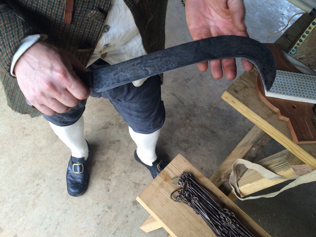
This hooky knife was a big part of surveying: you had to whack away enough underbrush so the surveyor and his crew could see each other. In the Carolinas, where Lawson surveyed? Not so easy.
Next, amazingly, was how much surveying was done by people who DIDN'T know the math. The surveyor would use complex equipment like the circumferentor, a surveyor's compass that enabled the surveyor to sight a distant object through slots called an alidade.
He would look through the sights and call to his assistant, who would stand where the surveyor told him and perhaps blaze a tree, stone, or other object while the surveyor noted on the circumferentor the exact angle to the object from his starting point. Then the surveyor would carry his equipment -- a tripod and his circumferentor -- to the spot, send his assistant to the next spot he wanted to sight, and begin again
He would look through the sights and call to his assistant, who would stand where the surveyor told him and perhaps blaze a tree, stone, or other object while the surveyor noted on the circumferentor the exact angle to the object from his starting point. Then the surveyor would carry his equipment -- a tripod and his circumferentor -- to the spot, send his assistant to the next spot he wanted to sight, and begin again
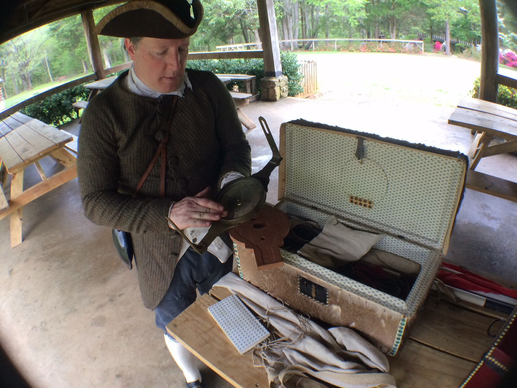
Loberger here holds his circumferentor.
Meanwhile, the chain gang -- they were actually called that -- would take surveyor's chains and measure the distance from point to point. A surveyor's chain was 66 feet long and consisted of 100 links, and the chain gang measured to the nearest link. With the surveyor measuring angles to the nearest degree and the chain gang measuring distance to the nearest link there was plenty of wiggle room, but when your landmarks are inherently nonpermanent things like trees, close enough will do.
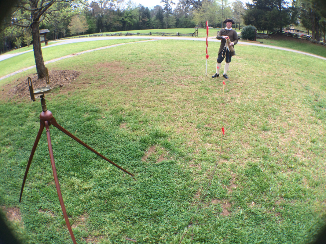
That's Loberger, showing about how far surveyors could get from one another. Those are arrows in the ground.
It only gets better. The chain gang measured by poking stakes -- called arrows, they were pieces of wood with a flutter of silk on the end, much like the stakes surveyors use even today -- in every time they reached the end of a chain. (Four rods per chain. The weird numbering comes because the surveyor's chain represents a genius-level metricization and combination of the ancient units of miles and acres. Long story; just trust me.)
Anyhow, the two assistants had quivers; the front one would have nine arrows, the back one none. The front one would stake an arrow into the ground at each chain, and when he ran out he would measure one more chain, then call "out," at which point the surveyor himself would note and track the out, whether on a special scorekeeper on his circumferentor or, lacking one of those, by moving a marker of some sort up the buttonholes of his waistcoat.
"An out was a unit of measure," Loberger told me. "You'd have one out and one arrow," he said, giving a possible measurement. So again: the chain gang did nothing more complex than count from one to nine (or ten, depending on whether you include "out"), and the design of the chains and links meant that simple multiplication yielded areas in acres. "The whole idea," he told me, "was to remove the mathematics." Being that the strong back was a bit more important than the strong mind. In places like Carolina, in fact, where brush was heavy, surveying crews often used half-chains instead of full chains so they could stay close enough to see and hear each other well enough to do their work. A half-chain is 33 feet, or a little more than ten yards. Which means it took a hooked machete, several pieces of equipment, and a crew of at least four to get a first down. Add in a guard and an instrument bearer and a couple guys to hold the staffs that were used for sighting to (and measuring smaller distances) and you can see that surveying took up a lot of energy of a lot of people.
An entire seized continent isn't going to carve up itself, right?
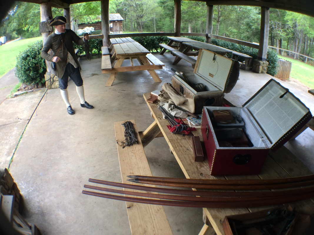
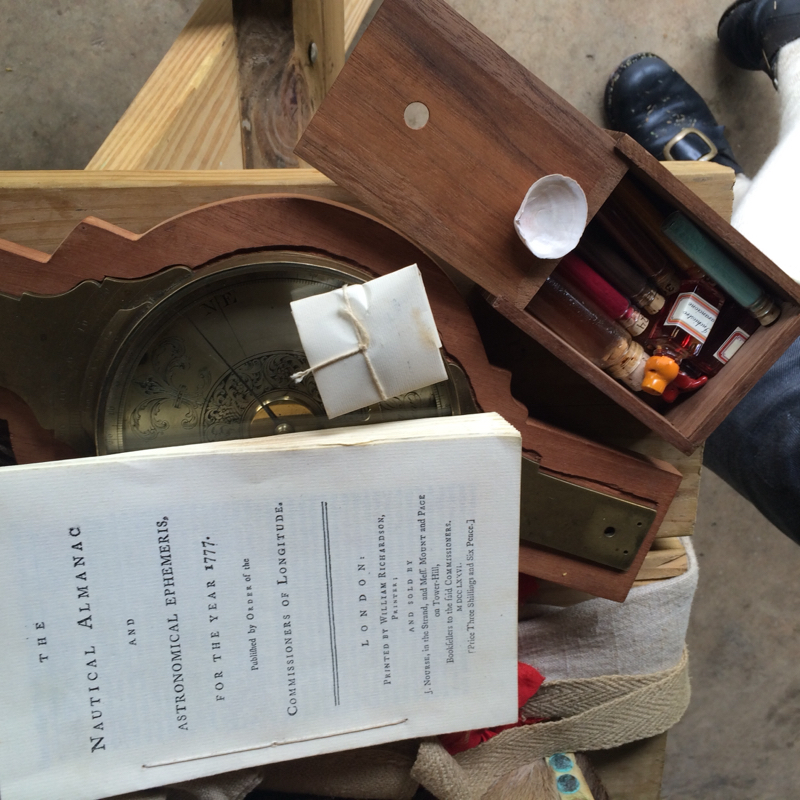
Boxes of surveying and drafting tools. Thank goodness for bearers!
But that's not even the cool part!
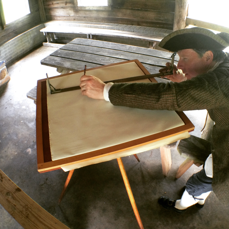
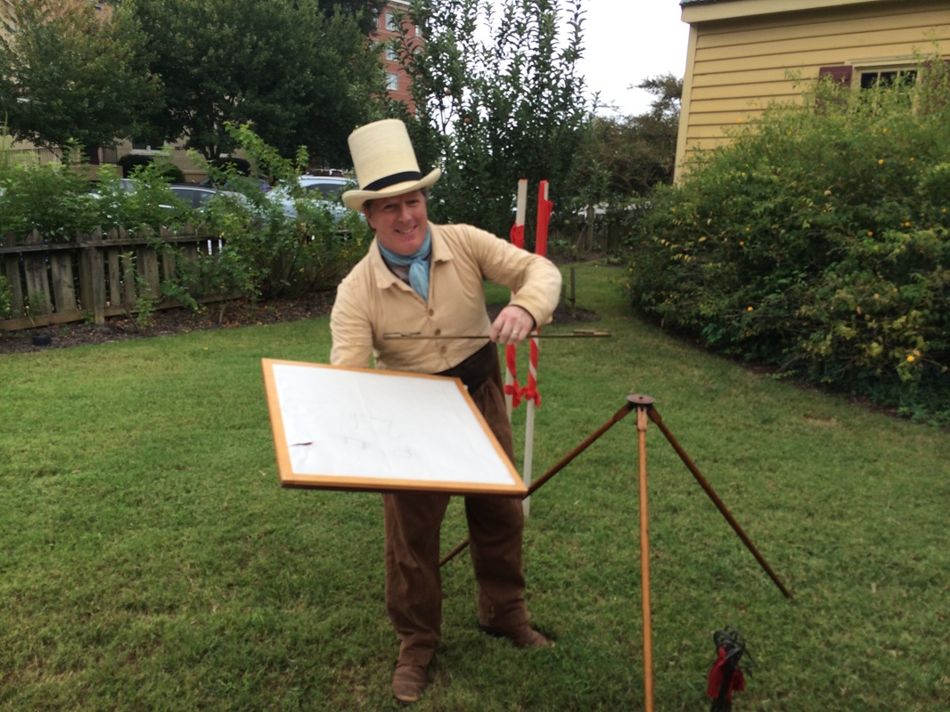
After demonstrating the use and lore of the circumferentor, Loberger pulled out the plane table and proceded to entirely blow my mind. With the plane table and a procedure called resection, a surveyor could map an entire area by taking sightings from two positions and end up with a perfect map of the area without leaving those two spots.
It's kind of insane, but let me explain. You take your plane table -- a flat surface on a tripod, basically -- and orient it towards the north. You may not need a compass -- you may just use a "needle box," a narrow box with 20 degrees of play or so for a compass needle. You orient the plane table, arbitrarily mark a spot on the paper on the table, and sight from there to several points, drawing a long pencil line along the straight edge of the alidade. Loberger demonstrated by sighting to the corners of the shelter in which we stood.
Then move the plane table, orient it exactly the same with the needlebox, and sight to the same spots, from a second arbitrarily chosen point on the paper. Your pair of pencil lines to each point will cross, and then you use a straightedge to connect the points where they cross.
Voila! You've mapped your site. Measure the distance between your two sighting spots, compare it to the distance between your sighting points on your map, and you've got your scale.
Mind blown.
It just doesn't seem right for something to be as intrinsically cool as the way a plane table can take points on the earth, place them on the plane in their exact proportional interrelationship, and result in a perfect map without your having to move beyond your two viewpoints. I mean, it's kind of crazy.
I could go on. Well, okay, I rather HAVE gone on, have I not.
Blame me, I dare you. Loberger also demonstrated the use of a sextant, with which observers on sea (or on land, with an artificial horizon, which I'd explain but your head might explode) could determine their position by measuring the height above the horizon of various celestial objects. (A predecessor to the sextant was the forestaff, which required you to squint directly into the sun as you measured its height above the horizon; ever wonder why pirates wore eyepatches? They were burning out their eyes. I am completely not kidding.)
The point is this: using technology available in 1700 and mathematics he would surely have known, Lawson was able to determine his position and, later, when he became the Surveyor-General of the Carolina Colony, parcel out land and design the towns of Bath and New Bern.
The point, really, is the do-ability of all this stuff. It wasn't magic -- it didn't require modern total stations and thousands of dollars of computing equipment. It required only the mathematics a young gentleman would know, a few pieces of equipment, and a little bit of want-to. You and I could do all of it with a pocket compass, a pencil, a pad, and a tape measure and come up with maps and measures that weren't all that ridiculous.
The world is amazing; the world Lawson wandered was perhaps even more so, because people hadn't yet forgotten that you could understand it so well by using mostly your brain, your hands, your feet, and your back.
Lawson's trail reminds me of all that. People like Dale Loberger stay reminded of that and try to remind the rest of us. You can still get the lay of the land.
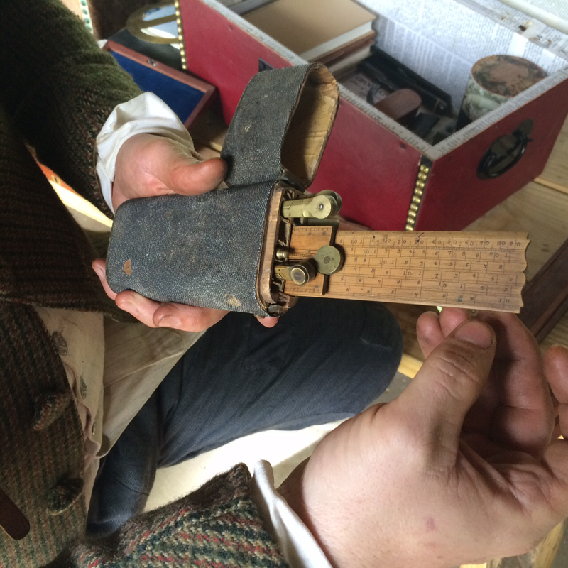
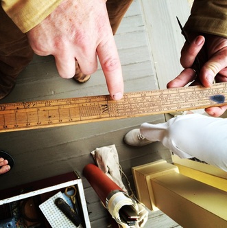
Seriously: the pocket surveyor's kit. Loberger is sure Lawson had one just like it.
Dyes for colors, statistics on where celestial objects would be, and all kinds of scales and rulers, to say nothing of rudimentary mechanical pencils and pens you made yourself out of quills. Please -- may I go on a surveying trip in the early eighteenth century?
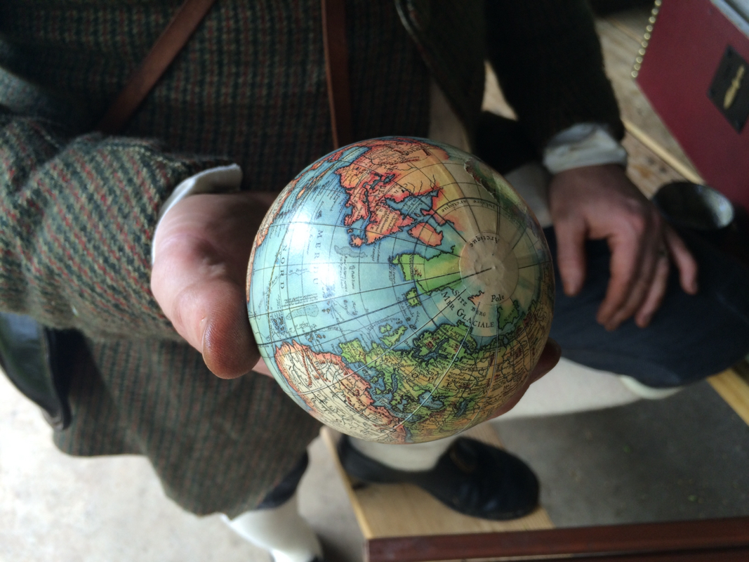
This is a reproduction, but Loberger is certain to the marrow of his bones that Lawson had one just like it: a little pocket globe, useful for pontificating in bars during discussions of matters political or geographical. I bet he's right. I mean, I'd have one. Wouldn't you?
 RSS Feed