The Lawson Trek
  • Home
    • About
    • Interactive Map
    • The Trek
  • Along the Path: Blog
  • John Lawson
    • "A New Voyage to Carolina"
    • The Carolina Colony
  • Talk to us!
  • Store
  • Press

Along the Path

Updates as we learned about Lawson's journey and times -- and reports from the trail as we progressed along it. Plus tales of the process of publishing the result.

The Lost Colony

7/28/2015

2 Comments

 
Picture
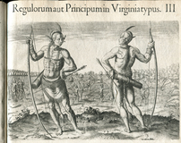
So yet another person has found the Lost Colony. Our pal Lawson would have snorted if he had shown up in modern times and heard the mysterious tale of the Lost Colony. 

You know the story: 1587, Roanoke Island. Over the previous couple years a very spotty history of English attempts to plant their very first colony ever has resulted in mostly death and disaster, but Sir Walter Raleigh sends a ship with another 115 or so colonists, ostensibly to go to the Chesapeake Bay in the Virginia colony, which then encompasses the whole coast of North America as far south as Cape Fear. They stop at Roanoke to see what has become of the previous garrison of soldiers left there a couple years before. Nobody's home, but instead of heading up to the Chesapeake the mission commander pretty much tosses them off the boat: you're colonizing here and that's it.

So they do -- John White, artist, mapmaker, and friend to the Queen, is in charge as governor, and they start trying to make sense of the place. White had been part of an earlier expedition, in 1585, on which he created a map astonishing even today in its accuracy and beauty. He also made a series of drawings that were the first ever of the coastal Indians, introducing them to English society.

Picture
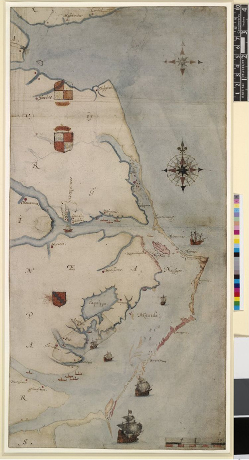
This is John White's map from 1585 of what is now the Carolina coast. The guy was paying attention, can we agree on that?
PictureSee? See? There they are -- right there!
Anyhow, in 1587 White and his settlers find themselves settling not Chesapeake but Roanoke Island, south of that. The previous expeditions had been of a decidedly military character, so the Indians with whom those explorers had fought didn't initially express much friendship to the new group; once Indians killed one of the colonists while he was crabbing, the colonists got worried. They sent White home to beg for assistance, which he does, leaving behind his family, including his grandchild, Virginia Dare, the first European child born on North America. It's not like he was going to be back in 45 minutes, so they made a general agreement: if they had to move, they'd leave word. If they had to leave under duress? They'd carve a Maltese cross into a tree. Going for their own purposes? They'd leave a note.

So White goes home -- and runs, inconveniently, into the Spanish Armada, or anyhow England's war with same in 1588. England wins, which is good for England, but that and the privateering that goes along with such things keeps everybody busy until 1590, at which point another ships heads off to Roanoke to see what's what.

Not much, that's what. Nobody left, and the word "Croatoan" carved into a post of the abandoned fort. No sign of a struggle. Also, "CRO" carved into a tree. Croatoan was the name of the nearby island we now call Hatteras, and the Croatan peoples there seem to have been largely friendly to the colonists. When White returned in 1590, in fact, he was overjoyed to see the carved words, believing they meant the colonists had joined the Croatans. They had plainly left without duress, and though the empty site of their previous camp was disturbed, White concluded this was the work of the unfriendly Roanoke Indians after the colonists had left.

Unfortunately, a storm was blowing up, and the sailors weren't willing to go to Hatteras to see what had happened, and that was it for that investigation. So no further information came from the colony until 1607, when the Jamestown colony in Virginia settled, and then everything got kinda wacky. John Smith -- yes, that John Smith -- heard when he was once captured that some of the colonists remained alive, and he even included locations on a map, eventually taken from him, that showed where he believed they were. He was told by others, though, that the colonists had been slaughtered. Other theories involve the colonists moving in with various other tribes -- the Lumbee have long held that some of their members descend from the Lost Colony -- or moving inland, with the discovery that a spot  on the White map covered an image of an inland fort causing something of a ruckus in 2012. 

Anyhow, an entire industry of Lost Colony theories now occupies a certain species of usually amateur historical thinker, so it would have delighted Lawson when, this very week, researchers from the Lost Colony Center for Science and Research announced that they believed they knew exactly what had happened. The colonists had decamped, headed inland, and set up shop in an area called Beechland -- it's now in the Alligator River National Wildlife Refuge -- and began farming sassafras, an important early export crop of the colonies, already interesting to Europeans by this time because they believed it cured syphillis, that earlier American export. Sir Francis Drake brought some sassafras to England in 1586, with the remainder of the previous Roanoke colony, and Sir Walter Raleigh did export it as early as 1602, so the idea that sassafras was behind the colony makes sense. Still, indeed an important export (second only to tobacco in the 1650s), but the theory has a few holes. How the colonists crossed 4.5 miles of open water to get to the mainland, for one, though certainly Indians could have helped. How they knew about where to begin a plantation is another. A third is why they would have carved a note saying they were going in the exact opposite direction on a tree for White to find.

The answer is the same one it usually is. Fred Willard, director of the Lost Colony Center, says the entire undertaking was an enterprise to farm and export sassafras, supported by everyone from Raleigh to Queen Elizabeth herself. Secrecy was at the core: "It was a huge, huge conspiracy," he says. Isn't it always?

Anyhow, I even bring this up because Lawson would have found the very notion of a "lost" colony laughable. He lived in a fracture zone -- where multiple cultures were coming together and mixing, with good and bad results. People lived and traded, fought and died, shared food and diseases, had children. Things got messy. Lawson actually addressed the entire Lost Colony business with barely a shrug, when talking about the Hatteras Indians.

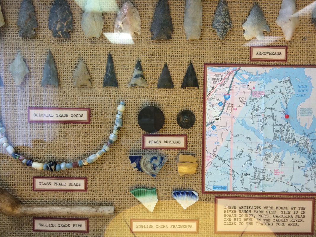
"The first Discovery and Settlement of this Country was by the Procurement of Sir Walter Raleigh, in Conjunction with some Publick-spirited Gentlemen of that Age, under the Protection of Queen Elizabeth; for which Reason it was then named Virginia,being begun on that Part called Ronoak-Island, where the Ruins of a Fort are to be seen at this day, as well as some old EnglishCoins which have been lately found; and a Brass-Gun, a Powder-Horn, and one small Quarter deck-Gun, made of Iron Staves, and hoop'd with the same Metal; which Method of making Guns might very probably be made use of in those Days, for the Convenience of Infant-Colonies.

        A farther Confirmation of this we have from the Hatteras Indians, who either then lived on Ronoak-Island, or much frequented it. These tell us, that several of their Ancestors were white People, and could talk in a Book, as we do; the Truth of which is confirm'd by gray Eyes being found frequently amongst these Indians, and no others. They value themselves extremely for their Affinity to the English, and are ready to do them all friendly Offices. It is probable, that this Settlement miscarry'd for want of timely Supplies from England; or thro' the Treachery of the Natives, for we may reasonably suppose that the English were forced to cohabit with them, for Relief and Conversation; and that in process of Time, they conform'd themselves to the Manners of theirIndian Relations. And thus we see, how apt Humane Nature is to degenerate.


I cannot forbear inserting here, a pleasant Story that passes for an uncontested Truth amongst the Inhabitants of this Place; which is, that the Ship which brought the first Colonies, does often appear amongst them, under Sail, in a gallant Posture, which they call Sir Walter Raleigh's Ship; And the truth of this has been affirm'd to me, by Men of the best Credit in the Country."


"The English were forced to cohabit with them, for Relief and Conversation; and that in process of Time, they conform'd themselves to the Manners of their Indian Relations." To me, in one sentence, that solves the entire mystery of the Lost Colony. You put a hundred or so people on a speck of an island off the coast of an entire continent, inhabited by people who already know you're willing to kill them if it strikes your fancy. Then you go off and leave them for three years -- and you act surprised when they're not exactly where you left them? Then they leave a note telling you where they went, but you wait another decade or two before you get there to see what's what. And then you act like it's a big mystery that somehow your hundred or so people have pretty much melted into the landscape. What did you expect?

Anyhow, it is forever a delight to see where Lawson's observations lead, and how important they are to everybody trying to understand the early days of the European and North American cultures mixing up.

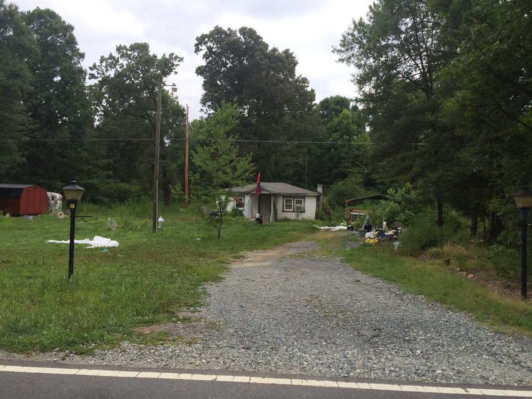
I'm going back on the road tomorrow. I'll let you know if I find any sassafras or any gray-eyed Indians.

2 Comments

The Hanging Tree

7/23/2015

28 Comments

 
PictureIf you're wondering, this is the house I was taking a picture of. No picture of my new friend -- he preferred not to.
So I'm taking a picture of a house along the Old Concord Road, which is pretty much what I do. I walk along the road, and I see a house or a field or a sign or a person that seems interesting or to have a story to tell and I take a picture of it or talk to the person or stop and jot a note down. Anyhow, I look like something between a private eye in a supermarket thriller and the way you thought a poet would look in high school -- floating down the street, pen in hand, scrawling deathless lines as I stroll.

And, as sometimes happens, someone comes over. I'm snooping or I have out a notebook or I'm pointing a camera, so somebody strides or drives over -- in this case drove, pulling smoothly but quickly into the drive directly in front of me. I don't remember what he said first -- tall slim white guy, probably late 60s, if I recall correctly smoking. Driving -- I can't believe how little I observed! -- some kind of long two-door, I THINK, probably domestic. I must have been asleep. Or at the very least paying attention to the house I was shooting.

Anyhow. "You okay?" he asks me, very polite and it's worth noting without a hint of threat or defensiveness. But it was his neighborhood -- he'd been shooting the crap with the guy across the street, at the car lot/produce market/cattle farm. I'd seen them talking as I walked past and felt like they'd noticed me. I usually would cross the street to speak with people like that, but they were deep in an asphalt parking lot by a big aluminum barn, and I just couldn't bear to walk a quarter mile with them wondering who the hell I was the whole time.

So I explained who I was and gave him my elevator pitch about Lawson and his book and my project and so forth and then we were friends. He said he had been an investigative reporter at the Independent Tribune, so we enjoyed talking about work. He told me most of the people on these roads -- in these communities -- are retired now, and the farms that are run are either keep-busy farms or rented out, with only few of the latter. We talked about the stories we have to tell, and then history came up, and then he mentioned that of course nowadays we're rewriting history, and then of course here we went on the Confederate flag.

I don't have to share the specifics. Some facts, as far as I can tell wrong (the owner of the most slaves was himself African American?); some commonly heard themes about historical revisionism and states' rights. Even a claim, new to me, that the war was fought over taxes. (I have to admit: if people have really begun to convince each other that the Civil War was fought over taxes, it may be game over. I thought of Marlon Brando in "Apocalypse Now" saying, "My god, the genius of that.") But anyway, a simple interaction. I stopped along the road, a fellow told me how the locals lived, shared what they thought. It was a perfect interaction for a reporter like me, on Lawson's trail to see what's out there.

We parted cheerfully, wished each other well without reservation. And for about 30 seconds I congratulated myself on simply reporting, letting the story come to me, instead of challenging. And then I thought, you know, with the murders and the flag and the cops and all this, though it's fine to listen to everybody I come across, I had better take care to hear other voices than the ones from the people whose houses were on the main streets I was walking down. I had better make sure I hear everybody's voices.

I mean not that this was new. Lawson mentioned the Huguenots by the river, and Huguenot descendants I found. Lawson talked extensively about Indians (everyone I've met in the Santee and Catawba tribes referred to themselves as Indians, and so I do as well), and I've made an effort to make sure I have talked to and about them as well.  I was stunned when I learned that for its first half-century, the slave port of Charleston made more money sending Indians to Barbados than it did bringing African and island peoples to the mainland, so this is good for me. I'm doing like Lawson did -- trying to get how things are here, how they've been.

So I decided that since the murders of African Americans, in churches or at the hands of police or private citizens, are so much in our discussions, I'd better make a special effort I got some African American voices in my chorus, and along I went.

The very next day I had a great opportunity. 

I walked my first day from the little not-even-crossroads of Mt. Gilead, just north of Concord, into Salisbury. There I was well entertained, as Lawson was by the Sapona Indians. The next day I started in Salisbury and walked through town to the northeast, walking down Long Street, quickly leaving the prosperous downtown and entering the town of  East Spencer, which I will describe with these images and this, directly from my notebook: "Long st a parade of the burned, the collapsed, and abandoned." I have a half-dozen similar images of burned-out buildings and houses. 

Picture
Also a school-free zone since the school burned down.
Picture
The cheerful town banner by the house with boarded windows almost physically hurts.
PictureCurtis on the left, Mike on the right.
A town of 1500 or so souls that has been losing population for 40 years, East Spencer is a place with problems: half its children in poverty, and a quarter of its elderly. Fewer than 700 families, 85 percent of which are African American, with a commonly cited number of more than 100 empty houses. A town of broken houses. And across Long Street, on a back porch, two guys having a chat. I walked over and met Mike and Tony, though Tony later told me his name was actually Curtis, and when I called the business card Mike gave me and asked for Mike, it was a wrong number, so he may have started out with a pseudonym too.

Anyhow, I introduced myself, shared business cards and pins and my little Lawson story -- and the story of the conversation of the day before. And off we went, cheerfully. In a town with the problems of East Spencer, Mike and Curtis did not think the Confederate flag was a big issue -- they were a lot more worried about employment, violence, and poverty and its attendant miseries. "As long as you keep a bunch of winos and run-down property in town," Tony said, you're not going to improve. They discussed water bills and troubled youth, irresponsible code enforcement and the failure to invest in the community. We never quite got to institutionalized racism and that sort of thing, but they said the makeup of the town was simple. Over in Spencer and Salisbury is where the white people and slave-owners had lived, and East Spencer was where the black people went -- literally on the other side of the tracks; enormous freights trundled through as we spoke. And they said it was within living memory that you were back across the tracks by nightfall if you knew what was good for you. As far as the flag went, Mike did say he actually approved of it: "I'd rather someone hung up the flag, then I know not to go there; I'll go somewhere else. Go there and I might get hung."

Mike had to leave -- he had started a nail salon, whose card he gave me -- but he expanded on that whole getting hung thing. He and Curtis had mentioned a boundary between East Spencer and Salisbury they called "the unemployment tree," and I was looking for a clarification on that, but I never got there because he brought up another tree. "Don't forget to see the hanging tree," he said, before he left. 

The what, now?

Yep: the hanging tree. I was to Google "lynching" and "Salisbury," and I would find an image of five men hanging from a tree, and the tree still stood on Seventeenth Street where it crossed the railroad tracks. Well, it's not five but three men hanging from a tree -- in 1906 -- and Seventeenth doesn't cross the tracks. Eleventh Street does, though. And according to this account (and map!) of the events, Eleventh Street was where I wanted to be. So I went there.

Picture
Picture
I'm not at all sure this lovely old tree is the right one. The point is far more important: the people in the community know that somewhere right there is where a white mob lynched three black men. I cannot imagine how one lives under these conditions.
I have no reason to be certain the tree I took a picture of is the one from which these three men -- one only 15 years old -- were lynched by a mob in August 1906, but if this tree is the wrong one, the right one is within a hundred yards or so. [Correction, 8-26-15: I'm told that there's considerable doubt about not only which tree but whether the tree stands at all; link through for a thorough discussion.] And here you can get a lot of background on the crime that led to the lynching, but that's not the point. The point -- the terrible point -- is that of all the historians and writers and people throughout the Salisbury area who showed me such enormous kindness, pointing me in the direction of old buildings and monuments, cemeteries and trails, the Trading Path and the Trading Ford, nobody outside the black community thought to say to me, "Don't miss the hanging tree." The black community? I spoke to two guys for twenty minutes and it came up and came up but good.

I spoke with Curtis for a while after Mike left, and then I went to see the tree. Around Eleventh Street there are warehouses and traintracks and such, but standing by itself was this tree, plainly old enough to have been large in 1906, and I watched it for a few minutes. No wreath, no flowers, no nothing -- just a tree, surrounded by a fence. It's not a symbol for Salisbury -- but it's a symbol for its black residents.

Anyhow off I went, along the path Lawson and I share.

Naturally, that turned out to be the day I saw a million Confederate flags, too. I took pictures.
Picture
This one in Denton doesn't leave much to the imagination. The dudes on the porch were super cheerful and closed the door so I could see the flag on it. There's an even bigger one flying above the house.
Picture
This house with its mess of a yard was surrounded by well-kept houses without Confederate flags, and I thought, "Well, at least his yard looks like his soul does." That's exactly what I thought.
So anyhow, I walked along, thinking my thoughts, until I passed the Pandemonium Performance motorcycle shop on Flat Swamp Road into Denton. There a large Confederate flag flew, and a small one, and a large American flag, and a sign saying, "You want to start something?" 

I most certainly did not. I got a curt nod from the guy out front and I didn't even take a picture. Except then I walked into Denton and thought, "I want to talk to the guy flying those flags." So I drove back, pulled over across the street, and shot a couple snaps. As I sat there the same guy walked out and asked: "You okay?" With overtones only of helpfulness. "I'm fine," I said, and asked if it was okay if I took some pictures. It was, and he urged me to park in his lot. "When I saw you stop, I worried you had broken down," he said. He was genuinely checking to see if I needed help.

So I told him my story. And we talked. "The reason is, to me that flag does not represent color," Kary, the shop owner told me. His some-number-of-greats-grandfather fought in the war, which was fought because "the North was trying to take what the South had, tell us we couldn't do what we wanted." Like, I pointed out, own slaves, a point he yielded.  But "to me, that flag represents me rebelling versus the government telling me what to do." He pointed to the American flag and said, "that's another thing about that flag -- you have the right to have an opinion."
Picture
"Want to Start Something?" Um, nuh-unh. I'll just be on my way if you don't mind. That is, I perceived this flag the way the vast majority of people perceive it, not the way the shop owner says he means it.
Picture
The Pandemonium Performance motorcycle shop near Denton. We talked about flags and racism and symbols and such. I walked away thinking these were nice people in this shop.
PictureThis is Kary. He owns the shop, though not the building. We had an awesome conversation.
To be sure; and to fly any flag you like, regardless of how others perceive it. The conversation continued and never, I need to be sure I am making clear, approached disrespect, threat, or even anger. We were discussing one of the matters of the day, and Kary laughed when I told him the "You want to start something?" sign had cowed me. Turned out it came from a rack of motorcycle batteries in the shop. Kary and I spoke respectfully, decently, and cheerfully. When Kary tells me he's not racist I believe him. I suspect that when I told him the flag is perceived as racist by just about everybody else, I think he believed me. He didn't change his actions, but he believed me.

In fact, when I tried to explain that whatever his personal beliefs, there was no doubt that millions of people took the flag as a symbol that he was a racist, he said he hated that. So I made a gesture, raising my middle finger, though pointing it at the wall, not at him. "What if I put that on a flag and waved it in your face?" I asked. He admitted that might offend him, and when I said, "What if I told you that though that middle finger is universally understood to mean disrespect and meanness, when I use it I just mean you should remember to have a digital exam to make sure you don't have prostate cancer? Because I'm worried about you?" He smiled and even laughed, nodding. He got the point.

He didn't take down his flag, mind you, but he got the point.

Anyhow. That was last week, and I look at the conversations of that day is among the most important I've had on the trek. Like Lawson I'm out trying to see what's out there, who's out there, what's going on, and at the moment, we are talking about this flag, and I'm walking through its home territory. Lawson walked through North and South Carolina. And it was South Carolina still flying the Confederate flag on its state capitol grounds until the Charleston church murders convinced their legislature to take it down. And it was North Carolina KKK members, don't forget, who came down to make sure nobody thought all Carolinians were civilizing. 

I was so glad for these conversations. Because I want it to be easy -- I want the house with the dirty yard and the flag to be symbolic of a Bad Person with Racist Views, and I want anybody who still flies that flag to be Bad and Wrong and Mean. I want it to be easy. But there were Mike and Curtis telling me that they were a lot more concerned about jobs and education and civic investment than in some flag, and they pointed me at the hanging tree. And there was Kary -- and so many like him whom I've met so often -- who genuinely believes that the flag is not a symbol of racism, and who genuinely believes, despite all the enormous, vast evidence that ths Southern states seceded to protect slavery and white supremacy, that the Civil War was fought over something other than slavery. (Here's the flag's designer, in his own words. Shudder.)

In fact, as a small aside, let me remind you that unlike Lawson, I am not having on my trek my first experience in this territory. I have lived here more than two decades, and I can remind you: people in the South? If nothing else, they are stubborn. Stubborn. With all the positive and negative things that word can carry. If you're wondering why people refuse to accept the unequivocal evidence that the war was about slavery and the flag was adopted as a symbol of white resistance to Civil Rights, try to remember that you may be dealing less with racism than with a streak of pure, gut stubbornness. That stubbornness is not unadmirable. Though I will say -- in this case it's horribly misguided.

We talk about the flag and the flag and the flag and the churches and blah blah blah but the reality is now, this very day, black people are being murdered in the streets. By criminals, by citizens, by amateur crimestoppers, by the police, over and over and over. There cannot be any doubt that this is a direct result of slavery and the war. And yet another black citizen is killed and we say, "Gracious me that's just terrible," and then we get into a long pointy-headed discussion about the damned flag.

Mind you: the flag should come down. Anybody who flies it? At the very least -- at the very least -- is saying, "I know that tens of millions of people will find this offensive, but I still think the fact that I can claim to my own satisfaction that I personally don't mean it that way outweighs the absolute certainty that those tens of millions of people will perceive this flag as racist and mean and vicious." This is at best selfish and at worst ... something much worse. We should take down the flag, and everybody flying one should know: people who look at you see Dylann Roof, not your great-whatever-great-grandfather, whether he personally owned slaves or not. By flying it you're choosing to side with the Dylann Roofs of this world. 

One more aside -- monuments. The monuments should stand, every single one of them. Salisbury itself has had some discussion over its downtown Confedereate monument, which some would like to have removed. I completely oppose such Stalinist whitewashing. Salisbury's monument to Confederate soldiers is actually quite lovely, but it's also physical fact. And though I agree with all who find offensive and even absurd its inscription that it commemorates men who died for "constitutional liberty and state sovereignty," I would never take it down. Instead I'd add a new plaque giving more responsible information. [Update, 2020: Not sure I still agree with this sentiment; please see a piece I wrote for Duke Magazine about building and monument renaming and removal.]

More important, I'd build an enormous monument around the Hanging Tree -- a monument to every African American person lynched, to every African American person terrorized during Jim Crow, to every African American person ruined by centuries of state-sponsored racism. In the first place, why would you not? In the second place, what visitor to the Southeast would miss the Salisbury Lynching Monument, if it existed? 

So that's it on flags, trees, symbols, and suggestions from the Lawson Trek. No answers, and certainly no easy shorthand. Flying the flag doesn't make you one of the racists -- but it certainly means that's who you're choosing to align yourself with. Anyhow that's what people are talking about right now, here in the Carolinas, where Lawson walked and where I walk along in his path.

28 Comments

A delicious Country

7/16/2015

1 Comment

 
Picture
When Lawson says this is a delicious country, it's hard to disagree.
From his enjoyment of the "Hills and Vallies" near present-day Charlotte and his "Lodgings by a Hill-side, that was one entire Rock" just north of Concord, Lawson continued up the Trading Path with John Stewart (the new Indian trader who had joined his party at the Catawba town), towards what is now Salisbury.

The area even then was something of a multimodal hub. Stewart had a string of horses; Lawson and his gang were traveling on foot; and at the Trading Ford of the Yadkin (then called the Sapona) River, traders met and changed goods. The Great Wagon Road, running from Philadelphia to Georgia and providing a route to settle the backcountry east of the Appalachians, and where they crossed, in 1753 Salisbury was founded. Location, location, location -- even Daniel Boone set out in 1769 for his adventures from Salisbury. George Washington slept in Salisbury. It became a rail hub with the Spencer Shops (now a transportation museum) right next door. Nowadays Salisbury has a lovely and thriving little turn-of-the-century downtown, and of course the nearby Trading Ford and High Rock Lake, a result of the dammed Yadkin. 

But what it really has is lovely territory. When Lawson and two of his companions took advantage of iffy weather to visit the Sapona town by the river, he begin to sing the land's praises as only Lawson could. "We pas'd through a delicious Country, (none that I ever saw exceeds it,)" he said. "Nor could all Europe afford a pleasanter Stream." He kvells about the rolling land covered with long leaf pines: "pleasant Savanna Ground, high and dry, having very few Trees upon it, and those standing at a great distance. ... A Man near Sapona may more easily clear 10 Acres of Ground, than in some places he can one." He also describes "One side of the River ... hemm'd with mountainy Ground, the other side proving as rich a Soil to the Eye of a knowing Person with us, as any this Western World can afford."

He wasn't exaggerating; I have been to this place.

My old pal and font of all Lawsonian information Val Green bid me contact Dr. Robert Crawford III, a seventh-(or so)-generation son of Salisbury, whose family has owned River Ranch Farm, on a spit of land between Crane Creek and the Yadkin, since not long after Lawson came through, though at this point both creek and river make up arms of High Rock Lake. Crawford drove me down Crawford Road (he helped create the road driving his father's 42 Chevy around fields when he was too young to drive on the road, he chortled) and offered me the use of his 200-year-old cabin (it has notches in the logs that once enabled settlers to shoot at Indians). He and his wife, Ann, and his associate historian Susan Sides kept me lodged, fed, and entertained during my stay.

Crawford doesn't have the slightest doubt about the Sapona town being on a vast cleared area of his farm -- he lay back his head one day while fishing decades ago and found an arrowhead. This began a lifetime of picking things up, which led to a collection of some 20,000 items -- simply picked up after plowing -- that he in 2014 sold to the Laurens County Museum. A small sampling hangs in his downtown Salisbury ophthalmology office.
Picture
Arrowheads, pipes, trade beads, crockery; this area has been settled pretty much forever. This is the tiniest sample of Dr. Crawford's collection.
Picture
So cute you could just wiggle, Salisbury seems to be thriving, not merely surviving.
Lawson talks of this area in a tone of voice he uses for no place else. "These Indians live in a clear Field, about a Mile square, which they would have sold me," he says, "because I talked sometimes of come into those Parts to live." He describes the river's "continual pleasant warbling Noise," says the coming spring "welcomed us with her innumerable Train of small Choristers ... redoubling, and adding Sweetness to their melodious Tunes by their shrill Echoes." The river, he says, is "hemm'd in with mountainy Ground" on one side, the other side "providing as rich a Soil to the Eye of a knowing Person with us, as any this Western World can afford."

That is, Lawson kind of liked it here.

Me too. Crawford's River Ranch Farm has an open spot very much like the one Lawson describes the Sapona living in, and from a spot in that area you can see, across the lake -- that would have been a river -- High Rock Mountain (it's only 1160 feet high but is still by far the highest point Lawson had yet seen in the New World), while on your other side, in a slough that is wet only because the lake is dammed now, would surely have been thick soil, enriched by occasional floods. The land is high and dry. Crawford pointed the spot out to me. His daddy told him Lawson had walked their land, and when Val Green showed up in his office one day asking for permission to visit the land it only made sense.
Picture
Crawford says he's had this cabin estimated to be more than 200 years old -- or it was where it was originally collapsing on his farm. He moved it and rebuilt it, adding basic conveniences. Then he lent it to me. Can you stand it? The Lawson Trek is getting exactly the same kind of hospitality Lawson depended on. And is just as grateful.
Picture
If you look through that little sort of window? in the middle? between the two main banks of trees? You can see a peak. I think that's High Rock Mountain, though Grist Mountain (1127 feet!) is nearby too. Anyhow, when Lawson talks about "mountainy Ground" on one side of the river, there it is.
PictureThere it is! just northeast of that big blob of Salisbury -- one path crossing the island and another going downstream of it. From the Collett map of 1770.
That sounds like a lot of "you are here," and it is. I bring it up only because for the first time on this trip informed sources disagree on where Lawson went and where things were. Ann Brownlee, of the Trading Ford Historic District Preservation Association, is unshakeably convinced that the Sapona town was across the river, nearer the Trading Ford itself, citing a survey by foundational North Carolina archaeologist Joffre Lanning Coe and on finding honey locust trees, which Lawson describes upon leaving the Sapona. Brownlee spent an afternoon with me showing me aspects of the Trading Ford. Though it's now unreachable by land because of a combination of the higher waters of High Rock Lake (another story), a highly private Duke Energy coal power plant (and attendant coal ash ponds -- yet another other story), and a railroad switching yard, the Trading Ford has been used since long before Europeans first visited the site in the 1500s; in fact, sites not far downriver have yielded relics carbon dated to be some 12,000 years old. The Trading Path led to it, and by the time the colonials began swarming the place and the Great Wagon Road and the Trading Path crossed at Salisbury, there were already two Trading Fords: the old Indian one, which crossed an island midstream, and the Colonial one, which passed the downstream tip of the island. 

Nobody doubts where the Trading Ford was; it shows up on countless maps. Brownlee works tirelessly on its behalf, maintaining a monument, working for historic preservation of bridges across it, and in general speaking for the Ford like the Lorax does for the trees. 

Just the same, Val Green hasn't let me down yet, plus I peeked through the trees and saw the mountain, plus I like Val's belief that the reason Lawson didn't cross the Yadkin (or Sapona) at the Trading Ford is because his party wanted to check out the mountains and so headed south, off the Trading Path. Brownlee believes -- as have almost all historians -- that he crossed at the Trading Ford, since it's where the Trading Path crossed the river. 

On this topic Lawson is himself no help. In fact, Lawson actually never says "we crossed the Sapona" -- it's a bit like in Heart of Darkness, where one minute Marlow is hanging around waiting for steamboat parts and the next paragraph the shore is slipping by -- it seems like a rather essential detail has been left out. (I've always thought the moment in "Apocalypse Now" where they drop the boat in the river by helicopter is Coppola's sly reference to this elision by Conrad; if you know I'm wrong about that please don't tell me.) Lawson tells stories about the Sapona king quieting a windstorm, about how that king lost one of his eyes, about how the Sapona constantly feasted him and his companions. Though my hosts were not Sapona, I could scarcely have been better lodged, entertained, guided, or feasted.

Anyhow. I'll tell you more about the trip from Concord to Salisbury later, but here's the point of all of it: Lawson loved this area, and the Sapona treated him like a king. I think this area is just as beautiful, and though the river has been dammed, the country is just as delicious, and I've been treated like a king. I'm sad to be heading on my way tomorrow. I'll keep my eyes open for honey locust.

1 Comment

Trapping Images of Wildlife

7/7/2015

0 Comments

 
Picture
Troi and me fooling around in front of a placed camera to see if its motion activation is working. Evidently it was. We were very mobile.
I spent a morning last week getting only the smallest amount of poison ivy with NCSU student Troi Perkins, a double major in zoology and fisheries and wildlife conservation. She came to me through zoologist Roland Kays of the Biodiversity Lab at the the North Carolina Museum of Natural Sciences. Kays's lab sorts specimens, identifies species, creates bird skins and the like (the day I visited the lab they were stuffing mice). It also, importantly, is part of the eMammal project, with the Smithsonian Institution, that uses camera traps to spot, track, and learn about mammals in the field. Each month Twitter hosts #CamTrapChat, if you're interested in the specifics.  (This month's is July 7 at 4 p.m. EST; here's a Storify of last month's.)

Anyhow Roland got interested in the Lawson Trek, and he offered to help us get a couple camera traps in the field to gather info on the animals that hang around a spot where Lawson was. Then we can leave them in the field for a few weeks, and when I walk to them I'll gather them back up and return them. Meanwhile, we'll see what we see.

Putting them in was a treat. For one thing, Troi and I got to take an awesome walk off trail and into the bush, though for obvious reasons I will not tell you where (I will once the cameras are back home safe). We stayed pretty safe on our first placement, but the second one took us into much less traveled places, and somehow I was idiot enough to wear short pants. Poison ivy let me know I had erred, though I saw it so I tiptoed a lot. Just a couple little itchy spots, if you're wondering.
Picture
Not hugging the tree; circling the cord that will hold (and lock) the camera to the tree.
Picture
Camera in place, checking time, batteries, location.
Picture
Camouflaged! And explanatory note.
Once we found places to put the cameras (we chose placements along Lawson's route and near water, hoping for good sightings; purely scientific placements would have been more random), Troi locked the cameras to trees, took accurate GPS locations, and then, with me, danced around in front of them to make sure their motion sensitivity was appropriately sensitive and they were pointed the right way. That's what you see at the top of this post. At night the camera uses an infrared flash, so it works all night long.
Picture
Got one! Raccoon sighting on the first night!
Though as Troi says, "no data is good data" when it comes to actual science and finding out what if anything is hanging around a particular area, we were thrilled when we caught this raccoon at our second placement on its very first night. 

Lawson saw raccoons too, and he had this to say about them: 

 The Raccoon is of a dark-gray Colour; if taken young, is easily made tame, but is the drunkenest Creature living, if he can get any Liquor that is sweet and strong. They are rather more unlucky than a Monkey. When wild, they are very subtle in catching their Prey. Those that live in the Salt-Water, feed much on Oysters which they love. They watch the Oyster when it opens, and nimbly put in their Paw, and pluck out the Fish. Sometimes the Oyster shuts, and holds fast their Paw till the Tide comes in, that they are drown'd, tho' they swim very well. The way that this Animal catches Crabs, which he greatly admires, and which are plenty in Carolina, is worthy of Remark. When he intends to make a Prey of these Fish, he goes to a Marsh, where standing on the Land, he lets his Tail hang in the Water. This the Crab takes for a Bait, and fastens his Claws therein, which as soon as theRaccoon perceives, he, of a sudden, springs forward, a considerable way, on the Land, and brings the Crab along with him. As soon as the Fish finds himself out of his Element, he presently lets go his hold; and then the Raccoon encounters him, by getting him cross-wise in his Mouth, and devours him. There is a sort of small Land-Crab, which we call a Fiddler, that runs into a Hole when any thing pursues him. This Crab the Raccoon takes by putting his Fore-Foot in the Hole, and pulling him out. With a tameRaccoon, this Sport is very diverting. The Chief of his other Food is all sorts of wild Fruits, green Corn, and such as the Bear delights in. This and the Possum are much of a Bigness. The Fur makes good Hats and Linings. The Skin dress'd makes fineWomens Shooes.


So, anyhow, yeah, the whole crab thing is a complete mokeyshine, and I have strong doubts about the business about drowning when trapped by oysters. Lawson was clearly telling tales he heard from Indians or, more likely, from other Europeans. One feels one is hearing a tenderfoot Boy Scout relating tales of his excitement chasing a left-handed smoke shifter. Part of the fun of this entire enterprise is seeing how what we see compares with what Lawson saw. Sometimes the terrain has changed; others it hasn't. Sometimes Lawson describes pretty much what we see, others he sees what he expects to see (like the crab-catchin' raccoon) or what cannot be there. He mentions a tiger later on -- and in the world's best footnote of all time, the editor of my edition says via footnote, "35. There were no tigers in this region." Well, technically, if the region you speak of is the entire Western Hemisphere, right, no tigers. Thanks for pointing THAT out.


In any case, camera traps! The Lawson Trek is on the case. 
0 Comments

Lawson at Nascar

7/3/2015

2 Comments

 
I'm not even kidding! Lawson's path took him right by where the Charlotte Motor Speedway sits now. He describes the rolling terrain of the day and perfectly captures the view from the speedway, at a natural crest where Route 29 and the road to Harrisburg meet. 

""Still passing along such Land as we had done for many days before, which was, Hills and Vallies, about 10 a Clock we reach'd the Top of one of these Mountains, which yielded us a fine Prospect of a very level Country, holding so , on all sides."

Which is exactly what you see from the Charlotte Motor Speedway: when you sit in the stands you get to see cloud shows and hills falling away beyond. I showed up on a Tuesday evening, which meant they had a bunch of small-scale racing going on, and I sat in the grandstand eating chips and drinking soda pop just as Lawson would have done, had he had the opportunity.
Picture
I had left Charlotte in the morning, dropped off by my friend Mike Graff of Charlotte Magazine. We talked about Charlotte's interesting history as a crossroads. As I mentioned last post, Lawson's group met an Indian trader there who was waiting for company before heading back northeast on the Trading Path, in this part of the world now more commonly known as Tryon Street, and where it crossed Trade, supposedly another trade route to the coast; their crossing is the highest point in the surrounding neighborhoods, which is why Charlotte still calls its downtown uptown, since residents had to walk uphill to get there.

Charlotte is the Carolinas' largest city and is really the only city with a big-city feel that Lawson would have passed, but even that doesn't last long. Ten minutes' walk from Trade and Tryon and you're in the North End, which welcomes you but offers mostly strip malls -- to say nothing of self-storage, vacant lots, and the homeless. 
Picture
Pretty pretty downtown!
Picture
Welcome to Not Downtown.
Picture
... which is still pretty close.
But what you get above all walking along the old Trading Path (it turns into Route 29, satisfyingly known as the Old Concord-Salisbury Road, around, natch, Concord)? You get car stuff. Cheap car lots, car repair, car parts, car tires, car rentals, car inspection, and "credit doctors" who will help you into a car you probably can't pay for. There is so much buying, selling, and maintaining of cars along these major roads that I have consistently found it hard to believe the auto industry accounts for only 3.5 percent of the U.S. gross domestic product. By the way -- I stumbled a few trips ago into the company in South Carolina that makes an enormous percentage of the giant signs you see all over the country at auto dealerships. I'll tell you all about them soon.

But: Nascar. Nobody needs to tell you Americans love cars, and the story of the growth of stock car racing is a remarkable tale of postwar American prosperity. So I found it delightful that Charlotte, at least, offers more than just parts and signs. The speedway was started in 1959 to cash in on the growing popularity of stock car racing, and construction went along just fine until the builders reached what Lawson probably could have told them, from walking the terrain, that they'd find: granite. "A half-million yards of solid granite," according to "Charlotte Motor Speedway: From Granite to Gold." That cost five times as much to cope with, and the speedway ran into the financial troubles that all enormous undertakings tend to have.

Anyhow, the region needed a speedway for the simple reason that stock car racing lives in central Carolina. You can find a million sources explaining how farmers growing corn learned that it was a lot cheaper to distill it and distribute it as whiskey than it was to transport and sell it as food, and how during Prohibition that meant delivering an illegal product. Which meant your car had to be faster than a police car but look perfectly normal. Add in that you needed cars that could rocket along straight stretches of highway but handle in both curving mountain roads during pickup and city streets during delivery and you've about covered every element of the racecars that fill the speedway.
So, anyhow, the day I walked through the speedway wasn't running some enormous Sprint Cup race, with 150,000 or so people clogging grandstand and infield. It was an event in the Summer Shootout series with small cars running on a quarter-mile oval along the frontstretch, with maybe a thousand fans paying eight bucks for a ducat and enjoying the wreckfest. Racing is always fun, but my point here wasn't racing, it was Lawson.

As I mentioned the spot is high on a ridge, and though the camping outside the track was hardly a thing of backwoods beauty, I managed to make a comfortable little home for myself even on a very hot night.
Picture
Hot and flat camping outside the Charlotte Motor Speedway. I didn't sleep much.
Picture
The night was hot enough that I barely slept, and when I awoke at 5 a.m. I downed a couple Pop Tarts, policed the campsite, and headed north at 6. I'm usually on the trail around 9:15 a.m. under any circumstances: if I wake at 7, I dither, and if I wake at 8:30 I rush. Lawson's guides felt the same, "Indians never setting forward 'till the Sun is an Hour or two high, and hath exhall'd the Dew from the Earth." But this day it was scheduled to be in the high 90s, and the urban heat island effect was something Lawson and his guides never had to deal with. But according to the EPA, asphalt can be 50-90 degrees fahrenheit hotter than surrounding temperature. I was walking in terrain not just changed from Lawson's day -- I was walking in a climate that simply did not exist in his day. He complained of freezing cold, and when I awoke one day months ago and saw the thermometer at 10 degrees I felt we shared something. What an environment of asphalt, concrete, and clear-cutting would yield would have been beyond his imagination.  Having lived it, I can tell you the answer is mostly as simple as the one the delightful and excellent biologist and writer Rob Dunn suggests in this piece about heat-mapping his walk to work: plant more trees. I'm here to tell you: walking along a bare asphalt berm can be miserable, and even in the hottest weather simply ducking under a tree makes an enormous difference. The planet hates strip malls and parking lots. Plant trees.

So anyhow, along Lawson and I went, north from the speedway towards Concord. Charlotte grew from a crossroads town to a textile town to a banking town and now is a big banking city. Concord's little twin brother, Kannapolis, was home of Cannon Mills and known as Towel City. and the walk north of the speedway to Concord was a study. For a long time in the heat that even at 7 am was brutal I passed racing-related shops -- restoration parts, cams, engine shops. Then came a long stretch of what I call the Anthropocene Suburban -- long stretches of road between small fields raising cattle or pines, the roadside ditches swaying with Queen Anne's lace, daisies and black-eyed Susans, primrose, Scutellaria (any of various purple-flowered mints), and dandelions. 

PictureThanks for the sandwich, Lobo!
Nearing Concord, however, I started running into empty textile mills advertising for tenants, though downtown Concord shows the combination of Charlotte-suburban growth mixed with small-town empty office blues. I ate a delicious sandwich at Ellie's, where Lobo, my waitperson, knew that the Trading Path worked its way through Concord. I love when people know that. Lobo also sent me to the First Presbyterian Memorial Gardens in Concord, which she said would be like visiting the gardens at Biltmore in Asheville. She was right! The church has owned the property since 1810, but the main church building moved, and by the 1930s the graveyard was neglected. In the 1930s the Williams family began restoring it, and 

now the garden covers nearly a full city block, with a half-dozen fountains and grave markers including everything from boulders to obelisks to plain old lovely stone slabs. At left is a glimpse of what you'll see if you go to visit, and take it from Lobo and me, you should.

So on I went, north of Concord to, as I mentioned, the delightfully named Old Salisbury Concord Road, where I quickly encountered something my old pal Val Green had bidden me to look out for: an 
enormous granite outcropping, right along the road, described by Lawson: "We went about 25 Miles, travelling through a pleasant, dry Country, and took up our Lodgings by a Hill-side, that was one entire Rock, out of which gush'd out pleasant Fountains of well-tasted Water." No gushing fountains now, though the rock face remains, running along the left of the road, sometimes covered in hanging foliage. I did not sleep there.

Along I went, though, until the road begin to diverge away from Kannapolis. That was as far as I cared to go in that blasting sun, having covered about twelve
Picture
Picture9 feet of bronze intimidation.
miles that day before 11 a.m., but also because I wanted to go to Kannapolis as well, though Lawson did not. In Kannapolis -- another onetime textile town trying to figure out what's next -- they're building a research campus and working to build on the success of North Carolina's Research Triangle Park between Raleigh and Durham (Lawson walked by; I live there and will walk by soon enough). Most important to me, though, after starting my trip in downtown Charlotte, where lies the Nascar Hall of Fame, and sleeping at the speedway, was the Earnhardt statue. 

One has surely heard of Dale Earnhardt, the Kannapolis native sone who became a legendary stock car racer, perhaps the best of all time. He died in a wreck at Daytona in 2001, but long before that the taciturn, stubborn competitor had become a symbol for the rural, Southern fans of Nascar's early explosive growth. When he died, though not everyone in mainstream culture understood this, in the South and across Nascar America it was like Elvis had died. Earnhardt's father, Ralph, was a racer -- racing was his way out of the Kannapolis textile mills he worked in. Earnhardt too was uneducated and headed for the mills, but his racing gave him a way out. His success on the track became a touchstone for generations of Carolinians, and his death broke hearts.

So in Kannapolis, if you go to downtown Kannapolis, you won't find a huge amount -- on the redevelopment scale it's behind Concord and nowhere near Charlotte -- but you will find a statue of Dale Earnhardt, in a little plaza built for that purpose. It's part of the Dale Trail, a collection of Earnhardt touchstones you can visit. You can visit Ralph's grave, the family's old neighborhood, roads named after Earnhardt, "Idiot Circle," the cruising area of Kannapolis, and of course the plaza, which has not just the 9-foot bronze statue but a granite monument and a circle of benches. You can also drive to race shops and stores and such, but you get the idea.  Lawson walked through here, describing the place to the world for the first time; no statue. Washington came through here on his tour of the South, solidifying the nation in the aftermath of the adoption of the Constitution. No statue.

Earnhardt drove race cars, and he gets a statue. I say this not in criticism but in description. You want to understand the South? Look at who the people raise up. In Camden, South Carolina, you see an awful lot of the Indian chief King Hagler, and you know why: he was a local.  Washington rode through; Lawson walked through. But Earnhardt was a local. Earnhardt Carolina loves. Let's hope they come to love Lawson as much.

2 Comments

    Archives

    January 2020
    October 2019
    May 2019
    February 2019
    November 2018
    October 2018
    May 2018
    March 2018
    August 2017
    May 2017
    August 2016
    June 2016
    March 2016
    February 2016
    November 2015
    October 2015
    September 2015
    August 2015
    July 2015
    June 2015
    May 2015
    April 2015
    March 2015
    February 2015
    January 2015
    December 2014
    November 2014
    October 2014
    September 2014
    August 2014

    Categories

    All
    Adventure
    African American
    Angie Clemmons
    Anthropocene
    Apothecary
    Appalachian
    Archaeologists
    Archaeology
    Army-navy
    Art
    Artifacts
    Atlanta
    Backpack
    Banking
    Barbecue
    Barry Beasley
    Bath
    Beaufort
    Beckee Garris
    Beetle
    Beginning
    Ben Franklin
    Berm
    Bill
    Birds
    Blister
    Book
    Bookstore
    Boston
    Botanical
    Boykin
    Breach
    Brent Burgin
    Brownlee
    Buck
    Buffer
    Cabelas
    Cambridge
    Camden
    Camera
    Canoe
    Canty
    Catawba
    Chain
    Charleston
    Charlotte
    Chelsea
    Chocolate
    Chris Judge
    Church
    Cincinnati
    City Of Raleigh Museum
    Civilization
    Coe
    Comment
    Community
    Concord
    Confederate
    Contentnea
    Cornwallis
    Country Music
    Couture
    Crawford
    Creek
    Croatoan
    Cutler
    Cypress
    Danger
    Davis
    Death
    Delightsome
    Delk's
    Denton
    Devices
    Drake
    Drawing
    Drunk
    Duck
    Durham
    Eagle
    Earnhardt
    Earth Day
    East
    Ecologist
    Effron
    Embankment
    End
    Error
    Evans
    Exhibit
    Expeditions
    Facebook
    Feather
    Fern
    Finish
    Fire
    Flag
    Flintlock
    Flood
    Francis
    French
    Gaillard
    Gander Mountain
    Garden
    Geology
    Gimpy
    GIS
    Google
    Great Wagon Road
    Green
    Greenville
    Grifton
    Guerry
    Gun
    Guns
    Haigler
    Hallenbeck
    Hampton
    Hanging
    Hannah Smith
    Harris
    Hartford
    Harvest
    Heat
    Hempton
    Highway
    Hillsborough
    Hips
    Historic Bath
    Hollow Rocks
    Home
    Homeness
    Hortus Siccus
    Hospitality
    Huguenots
    Huntley
    Indians
    Instagram
    Interstate
    Island
    Ivy
    Ivy Place
    Jamaica
    Jarvis
    Jennifer Landin
    Jered
    Jimmy White
    John Jeffries
    John White
    Journalism
    Kadaupau
    Kannapolis
    Katawba Valley Land Trust
    Katie Winsett
    Kayak
    Kershaw
    Keyauwee
    King
    Knife
    Lame
    Land
    Language
    Lawson
    Lawsonians
    Lecture
    Legacy
    Legare
    Legislators
    Leigh Swain
    Lenoir
    Lenoir Store
    Lenses
    Library
    Lichen
    Lies
    Loberger
    Locke
    London
    Longleaf
    Lost Colony
    Lynch
    Lynching
    Magnuson
    Mansplaining
    Maps
    Mass Shooting
    Match-coat
    Mathematical
    Meerkat
    Memorial
    Mental Floss
    Mill
    Millstone
    Miniature
    Monkeyshine
    Moonshine
    Museum
    Museum Day Live
    Musings
    Nancy
    Nascar
    Native American Studies Center
    Natural History Museum
    Nature
    Nesbit
    Netherton
    Neuse
    Newspaper
    Nonfiction
    Notebooks
    Occaneechi
    Orlando
    Pack's Landing
    Palmetto
    Pamlico
    Park
    Patent Leather
    Pedestrian
    Peggy Scott
    Periscope
    Petiver
    Photography
    Physic
    Pig
    Pig Man
    Pittsburgh
    Pocket
    Poinsett
    Polo
    Potsherd
    Pottery
    Preparation
    Presentation
    Press
    Process
    Proofreading
    Property
    Publishing
    Raccoon
    Racing
    Racism
    Racist
    Raleigh
    Rape
    Ray
    Readings
    Reconsideration
    Records
    Revolution
    Richard Smith
    Richardson
    Rights
    Riparian
    Rivulet
    Road
    Roadness
    Roanoke
    Robert Off
    Roland Kays
    Rolling Stone
    Roombox
    Rules
    Salisbury
    Santee
    Sapona
    Sassafras
    Scan
    Sconc
    Seneca
    Seth
    Shakespeare
    Sir Walter Raleigh
    Slavery
    Slime Mold
    Sloane
    Slope
    Small Town
    Smith
    Smithsonian
    Snow
    Sore
    Sounds
    Spanish Moss
    Specimens
    Speedway
    Spencer
    State Fair
    Steve Grant
    Stewart
    St. Mark's
    Suburban
    Sumter County
    Surveying
    Swamp
    Tar River
    Technology
    Textile
    Tide
    Tobacco
    Toms River
    Tool
    Towel
    Trade
    Trading Ford
    Trading Girls
    Trail
    Trap
    Traunter
    Tree
    Tree Farming
    Trek
    Trilobite
    Troi Perkins
    Truth
    Tryon
    Tupelo
    Turkey
    Tuscarora
    Twitter
    Ugly
    Unc
    Val
    Val Green
    Virginia
    Virginia Dare
    Virginia Historical Society
    Walking
    Washington
    Waxhaw
    Weather
    Website
    White
    Writing
    Wrong
    Yadkin
    Yoga

    RSS Feed

Proudly powered by Weebly