Honey, I'm home. But, as perfectly capped a long and rather unusual journey, the final steps were somewhat circuitous. Let me explain.
Let's start at the charming, art-filled Greenville home of Vince Bellis, retired professor of biology at East Carolina University, who at his retirement took on Lawson as something of a project. (Vince was responsible for getting photos of all of Lawson's botanical specimens in the Natural History Museum in London online in 2002, just a bit more than 300 years after Lawson's journey.) We talked about the unique ability of our friend Val Green to sort of sniff out an old road, especially the roads that comprised Lawson's route. Val of course is the man who has spent 40 years of his life figuring out where Lawson slept every night, and Val has guided my journey virtually every step. He drove me along a river road in South Carolina once, narrating: "You see here? to our right? that's the plateau; on our left? It slopes down to the river. That area would flood occasionally. That's why the road is here -- it's always been here."
And he was right -- he was teaching me how to see a road, whether it's gone from animal trail to Indian trail to trade path to wagon road to railroad or concrete or asphalt, like the one we drove on, or one that's remained a sand road for pretty much its whole history. Like Tom Magnuson and Dale Loberger, two other finders of the old ways, Val has just developed a nose. Vince and I wondered at it. To Vince, Val once described his pursuit of Lawson as "searching for the Ashes of Mr. Lawson's Campfires," and Vince wrote an unpublished paper about the end of Lawson's journey with that exact title. He gave me a copy, which does a great job of explaining where Lawson "came safe to Mr. Richard Smith's, of Pampticough-River, in North-Carolina; where being well receiv'd by the Inhabitants, and pleas'd with the Goodness of the Country, we all resolv'd to continue."
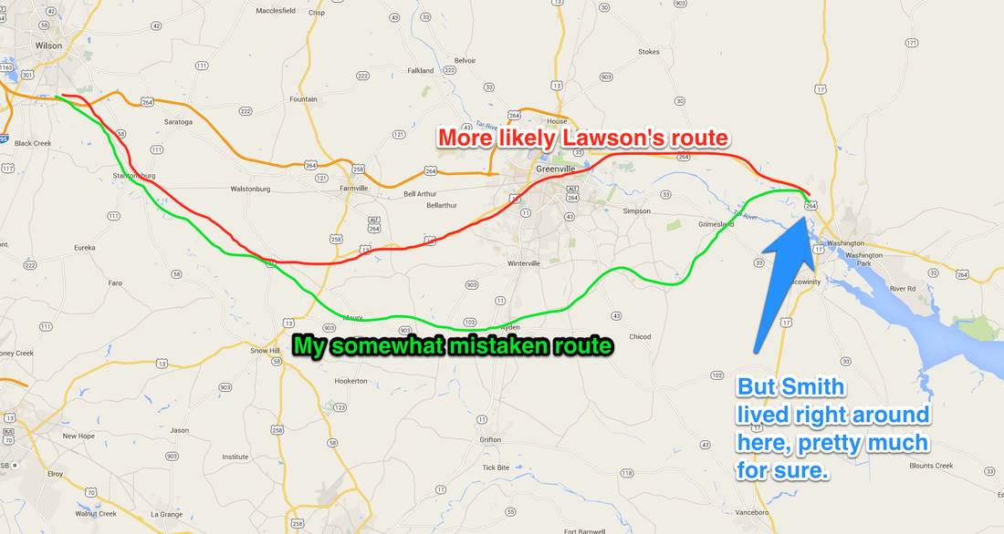
Agreeing with many before him who have believed that Lawson crossed the Tar River in the neighborhood of Greenville, Vince followed Lawson past "a deep Creek" that was most likely the Grindle Creek. Lawson says he walked about 12 miles before reaching the Smith place, and it is indeed about 12 miles from the eastern edge of Greenville to the east shore of Grindle. What's more, Vince found a land patent granted to Smith in 1706 that describes him already living on "Smith's Neck," which lay between two creeks. Now called Clark's Neck, the land between the Grindle and Tranter Creeks just to the east of Washington answers perfectly. Vince showed me where Smith would likely have lived, and I planned my next day's walk, which it turned out would actually be only a few miles.
And then we talked about how I could recover from the misdirection that had guided my last day or two's hikes.
Let's start at the charming, art-filled Greenville home of Vince Bellis, retired professor of biology at East Carolina University, who at his retirement took on Lawson as something of a project. (Vince was responsible for getting photos of all of Lawson's botanical specimens in the Natural History Museum in London online in 2002, just a bit more than 300 years after Lawson's journey.) We talked about the unique ability of our friend Val Green to sort of sniff out an old road, especially the roads that comprised Lawson's route. Val of course is the man who has spent 40 years of his life figuring out where Lawson slept every night, and Val has guided my journey virtually every step. He drove me along a river road in South Carolina once, narrating: "You see here? to our right? that's the plateau; on our left? It slopes down to the river. That area would flood occasionally. That's why the road is here -- it's always been here."
And he was right -- he was teaching me how to see a road, whether it's gone from animal trail to Indian trail to trade path to wagon road to railroad or concrete or asphalt, like the one we drove on, or one that's remained a sand road for pretty much its whole history. Like Tom Magnuson and Dale Loberger, two other finders of the old ways, Val has just developed a nose. Vince and I wondered at it. To Vince, Val once described his pursuit of Lawson as "searching for the Ashes of Mr. Lawson's Campfires," and Vince wrote an unpublished paper about the end of Lawson's journey with that exact title. He gave me a copy, which does a great job of explaining where Lawson "came safe to Mr. Richard Smith's, of Pampticough-River, in North-Carolina; where being well receiv'd by the Inhabitants, and pleas'd with the Goodness of the Country, we all resolv'd to continue."
Agreeing with many before him who have believed that Lawson crossed the Tar River in the neighborhood of Greenville, Vince followed Lawson past "a deep Creek" that was most likely the Grindle Creek. Lawson says he walked about 12 miles before reaching the Smith place, and it is indeed about 12 miles from the eastern edge of Greenville to the east shore of Grindle. What's more, Vince found a land patent granted to Smith in 1706 that describes him already living on "Smith's Neck," which lay between two creeks. Now called Clark's Neck, the land between the Grindle and Tranter Creeks just to the east of Washington answers perfectly. Vince showed me where Smith would likely have lived, and I planned my next day's walk, which it turned out would actually be only a few miles.
And then we talked about how I could recover from the misdirection that had guided my last day or two's hikes.
You can see I was off by a few miles ... somehow. I went back and re-followed the better route. With the exception of the Tar crossing at Greenville instead of further down, the two routes didn't strongly differ. I found myself greatly relieved.
Val has been my constant guide. We have spoken in restaurants and on trails, in cars and trucks and state parks and on the phone. And as I've come to each segment of my journey he's given me his interpretation of Lawson's route and helped me draw it -- in pencil -- on my DeLorme map book. And then I photocopy the requisite pages for each journey, and then off I go.
So when it was time to make my final journeys, I spent time with Val organizing my pencil lines, and then I confidently made my way. And when I sat with Vince, just to talk Lawson and get any final information I could about exactly where Lawson stopped before I made my final day's hike, we discovered I had wandered off. "Val has him walking right through the campus of ECU," Vince mentioned, and I shook my head. "Oh, no," I said. "Val has him walking south of Greenville, through the fields, and then up through Ayden and then north across the Tar, and then southeast into Washington." Or that's what I had on my book.
When I called Val to get to the bottom, Val sided with Vince: I had been somewhat off the exact track, if there is one, for the last couple days. We can't explain why, and we both remember our conversation in which we painstakingly penciled a line from Wilson, NC, to Washington, which is the end of the journey. We cannot for the life of us imagine how it came wrong. But it seems that I must have had an early version of Val's course; he says he's gone through several of those DeLorme books, and people used to believe Lawson had gone as far south as Goldsboro before heading north. So I suspect Val has been iteratively moving Lawson north, and I got version 5.3 instead of 5.5 or 6.0. In any case, when I went back to compare the two routes, with the exception of the river crossing in Greenville, the two routes passed through almost identical territory: flat, broad farms. As Lawson said, "the Country here is very thick of Indian Towns and Plantations." He also mentions how in this area some of his companions, invited by Indians, went to visit their town: "but got nothing extraordinary, except a dozen Miles March out of their Way." You guys, I'm hip.
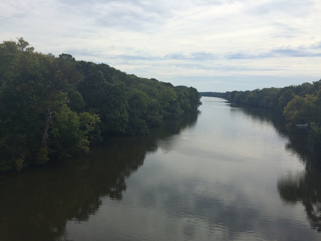 "In the afternoon we came to the banks of Pampticough.... The Indian found a Canoe, which he had hidden, in which we all got over." The Tar River, as it reaches the Pamlico Sound. I crossed it probably a few miles east of where Lawson did. I used a bridge. | 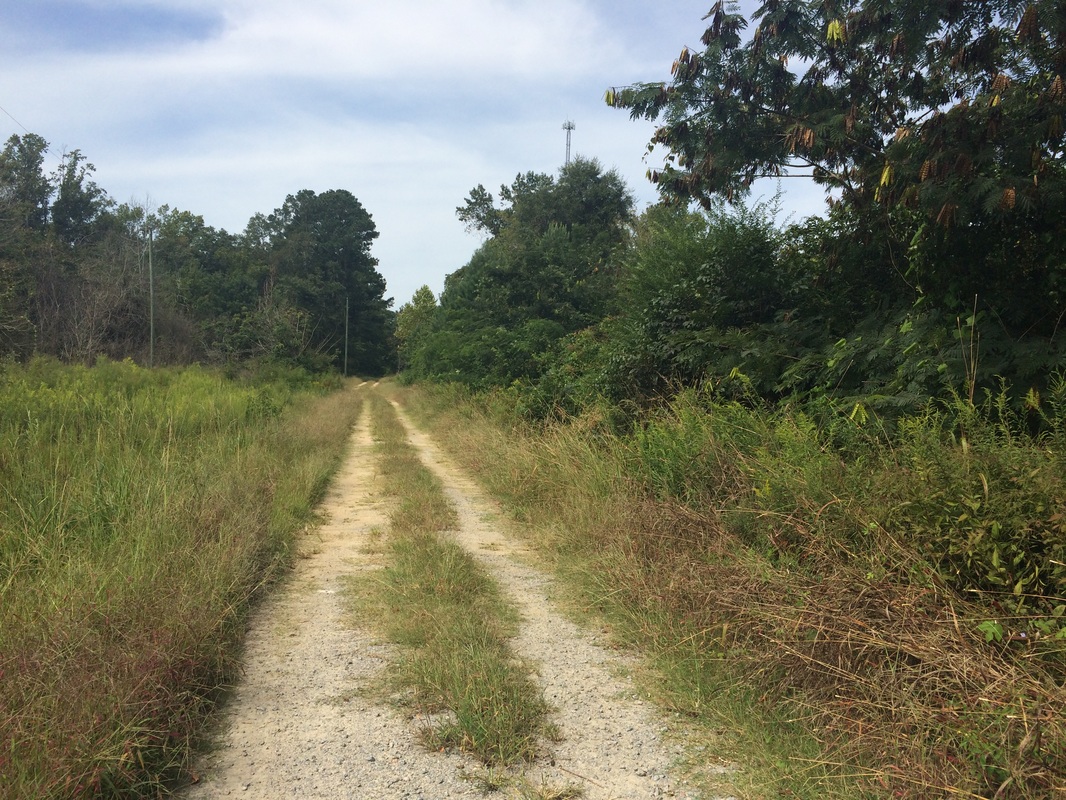 This little spot of land, east of the Grindle, had a kind of speak-to-me that I think of as homeness. When I went to the other side of the river I stopped at a place that felt similarly homey -- and when I looked on Google Maps I saw I was very near to the first place. Homeness indeed. |
I solved my problem -- if it is a problem -- by going back over, mostly by car, the alternate path. Much of a muchness -- with the exception of the crossing in Greenville, the terrain is the same: farms, vast acres of crops, old houses and barns. It's a beautiful place. In Greenville you cross the Tar by a greenway or a downtown park, then walk east on a long exurban street with the same kind of empty buildings and decaying sprawl I've seen throughout the Carolinas outside the cities and towns; in the long run I'm glad I ended up spending more time in the country.
But I did reach the Tar, if a few miles east of where Lawson probably did. And I did cross it, and then, east of the Grindle Creek, I began casting about. For a half mile or so the terrain is swamp; once it raises up a tad you start to feel a sort of firmness beneath your feet, and you feel it: this is a place people could stay. They could make a home here, clear land, grow food, hunt. This is a good place.
I can't say I found for sure the Smith place, though the little double-track dirt road leading into the bush felt perfect, and when I went to the other side of the creek and found a similarly "homey" place, it turned out to be exactly across the river. And when I walked down Clark's Neck Road, through the land that Smith surely owned, it felt much the same. This was home. This was the Smith land. This is where Lawson stopped. And it was where I stopped too.
For a minute.
Because the active walking part of this trek is over, but lots more remains. For Lawson the next years were about making his way in a new world. He found ways to be helpful to the powerful and the connected. He stayed with the Smiths -- he even evidently took Smith's daughter, Hannah, as his common law wife and had a daughter with her. He co-founded Bath, North Carolina's first incorporated town, and then New Bern, which eventually served as de facto capital. All that land-grabbing and town-founding eventually got him killed, but that's not the point now. The point is after his long walk, Lawson got -- and stayed -- busy.
So will I. My next steps will be to organize the records of my journey, both on this website and as a book. I'll keep the blog posts coming as I do that, sharing information I find, stories (so many!) I have not had time to share as I've walked, and keeping you posted on the development of what will I hope be a book worthy of Lawson's original.
In any case, for now, I'm done walking. I won't miss the blisters, but I'll miss the countryside. I'll miss the people, and the hills, and the farms and fields. I'll miss the rivers and creeks and cypress-tupelo swamps. I'll miss the sound and the coast, the ocean and the sandy pocosins nearby.
And I'll see some of you at 2 pm in Bath on September 26 for the (free!) Smithsonian Magazine Museum Day Live, for which the Lawson Trek will make a ceremonial canoe into town and tell a story or three.
But for now all I can say is what I presume Lawson said when he first saw the comely Hannah:
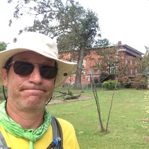
I'm home.
But I did reach the Tar, if a few miles east of where Lawson probably did. And I did cross it, and then, east of the Grindle Creek, I began casting about. For a half mile or so the terrain is swamp; once it raises up a tad you start to feel a sort of firmness beneath your feet, and you feel it: this is a place people could stay. They could make a home here, clear land, grow food, hunt. This is a good place.
I can't say I found for sure the Smith place, though the little double-track dirt road leading into the bush felt perfect, and when I went to the other side of the creek and found a similarly "homey" place, it turned out to be exactly across the river. And when I walked down Clark's Neck Road, through the land that Smith surely owned, it felt much the same. This was home. This was the Smith land. This is where Lawson stopped. And it was where I stopped too.
For a minute.
Because the active walking part of this trek is over, but lots more remains. For Lawson the next years were about making his way in a new world. He found ways to be helpful to the powerful and the connected. He stayed with the Smiths -- he even evidently took Smith's daughter, Hannah, as his common law wife and had a daughter with her. He co-founded Bath, North Carolina's first incorporated town, and then New Bern, which eventually served as de facto capital. All that land-grabbing and town-founding eventually got him killed, but that's not the point now. The point is after his long walk, Lawson got -- and stayed -- busy.
So will I. My next steps will be to organize the records of my journey, both on this website and as a book. I'll keep the blog posts coming as I do that, sharing information I find, stories (so many!) I have not had time to share as I've walked, and keeping you posted on the development of what will I hope be a book worthy of Lawson's original.
In any case, for now, I'm done walking. I won't miss the blisters, but I'll miss the countryside. I'll miss the people, and the hills, and the farms and fields. I'll miss the rivers and creeks and cypress-tupelo swamps. I'll miss the sound and the coast, the ocean and the sandy pocosins nearby.
And I'll see some of you at 2 pm in Bath on September 26 for the (free!) Smithsonian Magazine Museum Day Live, for which the Lawson Trek will make a ceremonial canoe into town and tell a story or three.
But for now all I can say is what I presume Lawson said when he first saw the comely Hannah:
I'm home.
 RSS Feed